OUR SURROUNDINGS
The cortijo is located in the center of the Geopark of Granada, of which we are an official information provider and collaborator. It is part of the municipality of Freila, Granada. The cortijo is situated in the vicinity of the Sierra de Baza Natural Park, as it is located on the erosion slopes or foothills of the park. It is very well-connected, just 5 minutes from the A-92 highway, 20 minutes from Baza, 15 minutes from Freila, 10 minutes from El Baúl, and surrounded by areas of great natural, cultural, and geological interest that have earned it recognition from UNESCO.
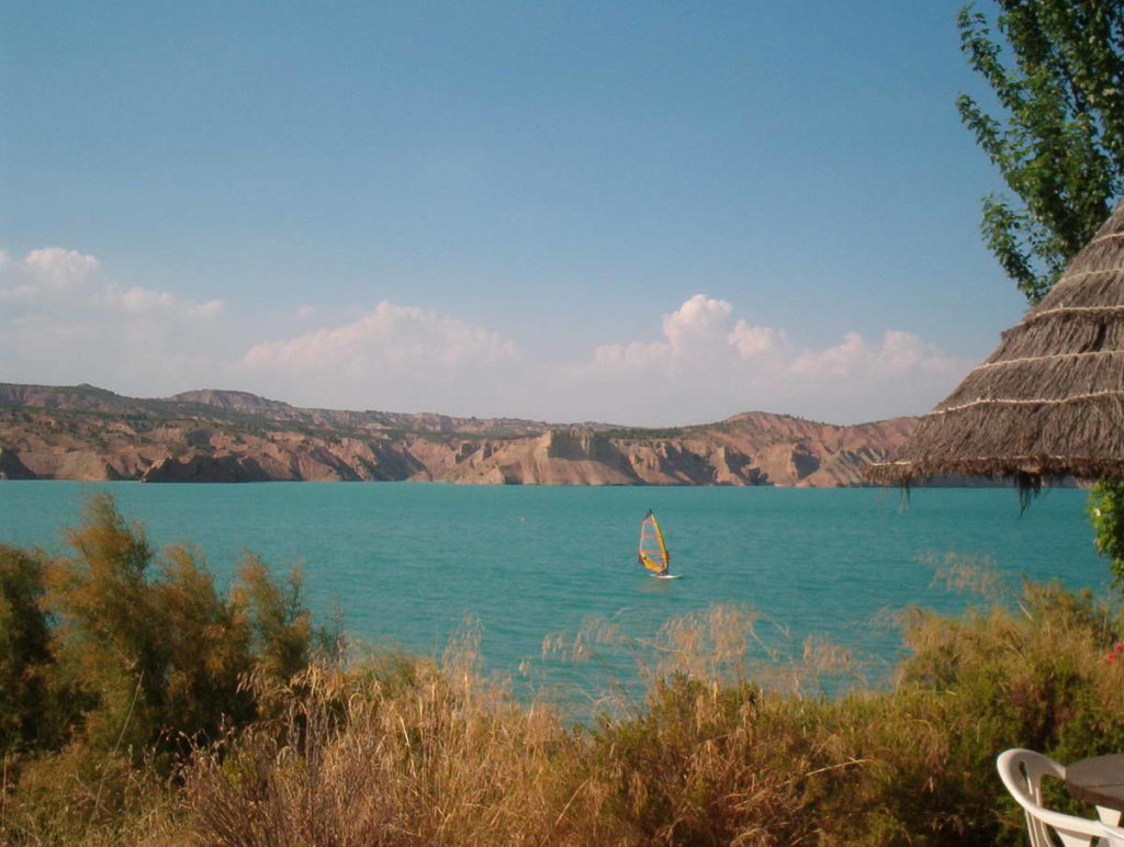
Its privileged geographical location offers first-rate tourist attractions such as water activities like surfing, canoeing, swimming, and fishing in the Negratín reservoir, as well as nature activities like hiking, birdwatching, in the Sierra de Baza Natural Park, and excursions in the Gorafe Desert. In addition, it is close to the Natural Parks of Castril and Cazorla, Segura y Las Villas, as well as the archaeological sites of Orce, Galera, and Gorafe. It also provides easy access to cultural routes and archaeological sites in Baza, Guadix, and Granada, including the spectacular Alhambra.
Freila
It is the smallest village in the Baza region, located in the center of the Geopark of Granada. It has managed to preserve its urban layout with winding streets of Moorish heritage, neighborhoods of caves built around ravines, a rich gastronomy, and deep-rooted traditions. It covers an area of 74.5 km2 with an average elevation of 804 meters above sea level and a population primarily engaged in agriculture, specifically the cultivation of tomatoes, almonds, and olives.
Freila has a history dating back to prehistoric times, as evidenced by archaeological remains found in the Cueva de las Ventanas. However, the current configuration of the village is largely attributed to the Arab period when the town experienced significant development due to its border location with the Adelantado de Cazorla. From this era, notable features include its fortress, the Maruq tower, and the characteristic layout of narrow and winding streets.
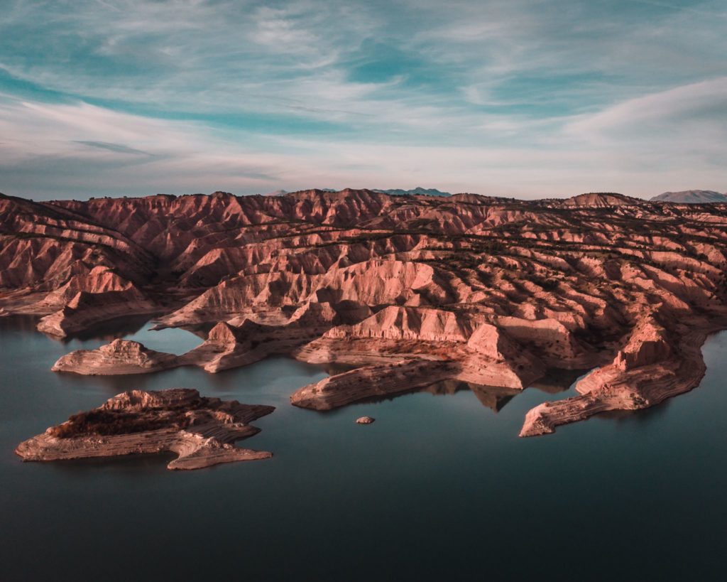
Freila likely derived its name from the goddess Froyla, possibly an Arab goddess of fertility. This association with fertility is quite fitting considering the lush valley, nourished by fresh waters, where olive trees, fruit trees, mulberries, and various garden produce thrive amidst an almost desert-like landscape, resembling an oasis. Today, the continued existence of this fertile plain is truly beautiful, with the Negratín Reservoir as a vast inland lake that contrasts the endless blue water with the strikingly red and arid Martian-like lands. The caves, serving as ancestral homes, maintain the charm of their potted plants and white facades, while the farmhouses stand as remnants of a not-so-distant past where one can still sense the toil, the sickle, the rustic bread, the hard work, but also the joy of the harvest. All of these elements make Freila a municipality that seeks to evolve while retaining the charm of its past.
Iglesia de la Anunciación
The Church of the town, which dates back to the 16th century, was erected by the Diocese of Guadix-Baza in honor of the Virgin of the Annunciation. It is located on the right bank of the Freila ravine, on the edge of a ravine, from where one can see the farmlands of the Vega, the Negratín Reservoir, and the Pozo District.

Castillo
It is located in the current castle district, which is accessed through the church square and Adolfo Quiles Cervera Street. Dating back to the 12th-13th centuries, it consists of an impressive rubble masonry tower, an cistern with traces of “almagra” (a reddish pigment), battlements, and a walled perimeter. This construction cannot be understood as isolated but was part of a complex defensive system that involved the neighboring castles of Zújar and Bácor, as well as the three watchtowers the municipality had. Their purpose was to protect the left bank of the Guadiana Menor, defending the Muslim border against the advance of the troops of the Adelantado de Cazorla.

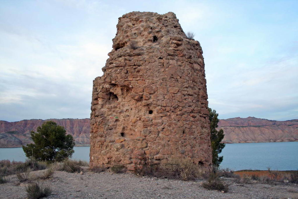
Torre del Maruq
This monument is defined as a watchtower or “almenara” (beacon), and its mission was essentially to watch over and warn the populations of any danger that threatened them, using smoke signals during the day and bonfires at night.
Caves
We recommend taking a stroll through neighborhoods like El Pozo, El Paraíso, or El Castillo, where you can witness the close relationship between humans and the environment, which is the main theme of the history of this region. You’ll find caves with a single floor, facing inwards, typical of the Muslim era, as well as multi-story caves facing outward, characteristic of the Christian period, with chimneys carved into the rock and the prominence of their small squares.

Negratín
It’s a place of unique and unusual beauty, as it features a large lake surrounded by a semi-desert landscape, almost Martian in appearance, creating a romantic and endearing scenery, especially at sunset. At the Negratín Reservoir, you can engage in water sports such as kayaking, sailing, windsurfing, rowing, swimming, and sport fishing.
Bad-lands
The peculiar orographic formation of the area is characterized by very distinctive features, including gullies and ravines eroded by the action of torrential rains. This terrain displays a range of colors from reddish to purplish, depending on the season and the lighting conditions. Another noteworthy characteristic is its extreme aridity and sparse flora, with a predominance of shrubs, esparto grass, and low-lying vegetation.